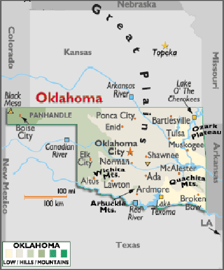
Map of Oklahoma, USA
Oklahomais located in the south-central region of the United States of America, a part of North America – Oklahoma is bordered by the states of New Mexico, Colorado, Kansas, Missouri, Arkansas and Texas.
Capital City: Oklahoma City
Location: 35º 28′ N, 97º 30′ W
Largest City: Tulsa
Location: 36º 06′ N, 95º 54′ W
Oklahoma geographical area and extent:
Oklahoma is situated in the western south-central US, Oklahoma ranks 18th in size among the 50 states.
The total area of Oklahoma is 69,956 sq mi (181,186 sq km), of which land takes up 68,655 sq mi (177,817 sq km) and inland water 1,301 sq mi (3,369 sq km). Oklahoma extends 464 mi (747 km) E-W including the panhandle in the NW, which is about 165 mi (266 km) long. The maximum N-S extension is 230 mi (370 km).
Oklahoma is bordered on the N by Colorado and Kansas; on the E by Missouri and Arkansas; on the S and SW by Texas (with part of the line formed by the Red River); and on the extreme W by New Mexico. The total estimated boundary length of Oklahoma is 1,581 mi (2,544 km). The state’s geographic center is in Oklahoma County, 8 mi (13 km) N of Oklahoma City.

You must be logged in to post a comment.