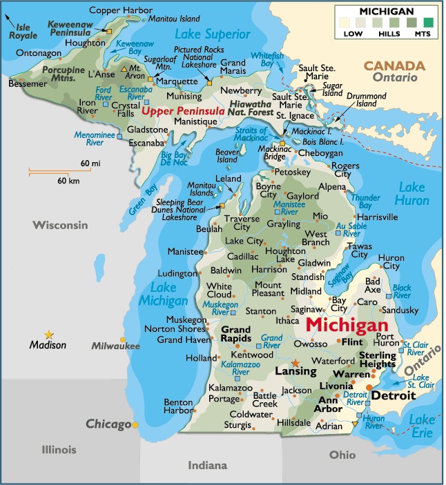
Map of Michigan, USA
Capital City: Lansing
Location: 42º 73′ N, 84º 55′ W
Largest City: Detroit
Location: 42º.33 57′ N, 83º 04′ W
Michigan geographical area and extent:
The total area of Michigan (excluding Great Lakes waters) is 58,527 sq mi (151,584.93 sq km), of which land takes up 56,954 sq mi (147,510.86 sq km) and inland water 1,573 sq mi (4074.07 sq km). The state consists of the upper peninsula adjoining three of the Great Lakes—Superior, Huron, and Michigan—and the lower peninsula, projecting northward between Lakes Michigan, Erie, and Huron. The upper peninsula extends 334 mi (538 km) E-W and 215 mi (346.15 km) N-S; the lower peninsula’s maximum E-W extension is 220 mi (354.2 km), and its greatest N-S length is 286 mi (460.46 km).
Michigan’s upper peninsula is bordered on the N and E by the Canadian province of Ontario (with the line passing through Lake Superior, the St. Marys River, and Lake Huron); on the S by Lake Huron, the Straits of Mackinac separating the two peninsulas, and Lake Michigan; and on the SW and W by Wisconsin (with the line passing through the Menominee, Brule, and Montreal rivers). The lower peninsula is bordered on the N by Lake Michigan, the Straits of Mackinac, and Lake Huron; on the E by Ontario (with the line passing through Lake Huron, the St. Clair River, Lake St. Clair, and the Detroit River); on the SE by Ontario and Ohio (with the line passing through Lake Erie); on the S by Ohio and Indiana; and on the W by Illinois and Wisconsin (with the line passing through Lake Michigan and Green Bay). The state’s geographic center is in Wexford County, 5 mi (8 km) NNW of Cadillac.
Among the most important islands are Isle Royale in Lake Superior; Sugar, Neebish, and Drummond islands in the St. Marys River; Bois Blanc, Mackinac, and Les Cheneaux islands in Lake Huron; Beaver Island in Lake Michigan; and Belle Isle and Grosse Ile in the Detroit River.The state’s total boundary length is 1,673 mi (2,693.53 km). The total freshwater shoreline is 3,121 mi (5,024.81 km).


You must be logged in to post a comment.