Map of Maryland, USA
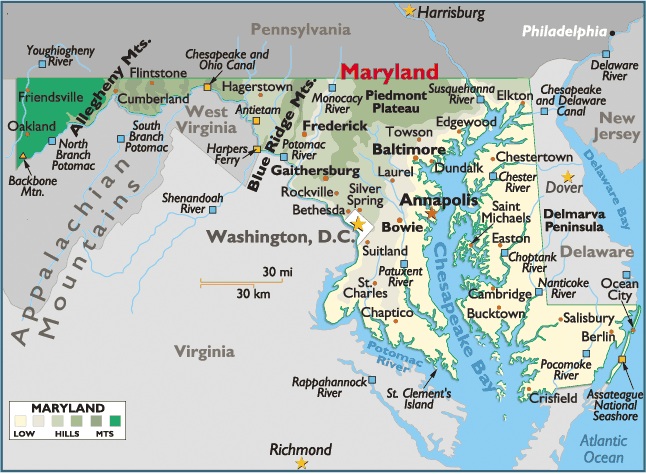
Maryland is located in the South Atlantic region of the United States. It’s bordered by the states of Virginia, West Virginia, Pennsylvania and Delaware and by Washington, D.C., and the Chesapeake Bay.
Capital City: Annapolis
Location: 38º 98′ N, 76º 48′ W
Largest City: Baltimore
Location: 39º 29′ N, 76º 61′ W
Maryland’s total area—10,460 sq mi (27,091.40 sq km)—comprises 9,837 sq mi (25,477.83 sq km) of land and 623 sq mi (1,613.57 sq km) of inland water. The state extends 199 mi (320.39 km) E-W and 126 mi (202.86 km) N-S.
Maryland is bordered on the N by Pennsylvania; on the E by Delaware and the Atlantic Ocean; on the S and SW by Virginia, the District of Columbia, and West Virginia (with the line passing through the Chesapeake Bay and Potomac River); and on the extreme W by West Virginia. Important islands in Chesapeake Bay, off Maryland’s Eastern Shore (the Maryland sector of the Delmarva Peninsula), include Kent, Bloodsworth, South Marsh, and Smith.
The total boundary length of Maryland is 842 mi (1,355.62 km), including a general coastline of 31 mi (50 km); the total tidal shoreline extends 3,190 mi (5,136 km). The state’s geographic center is in Prince George’s County, 4.5 mi (7.25 km) NW of Davidsonville.

District of Columbia, Maryland USA


You must be logged in to post a comment.