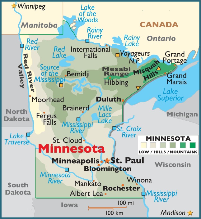
Map of Minnesota, USA
Minnesota is located in the North Central (or Midwest Region) of the United States of America – a part of North America – Minnesota is bordered by the states of North Dakota, South Dakota, Iowa and Wisconsin, the Canadian provinces of Manitoba and Ontario, and by Lake Superior.
Capital City: Saint Paul
Location: 44º 57′ N, 93º 06′ W
Largest City: Minneapolis
Location: 44º 59′ N, 93º 16′ W
Minnesota geographical area and extent:
The total area of Minnesota is 84,402 sq mi (218,601 sq km), of which land accounts for 79,548 sq mi (206,029 sq km) and inland water 4,854 sq mi (12,572 sq km). Minnesota extends 406 mi (653 km) N-S; its extreme E-W extension is 358 mi (576 km).
Minnesota is bordered on the N by the Canadian provinces of Manitoba and Ontario (with the line passing through the Lake of the Woods, Rainy River, Rainy Lake, a succession of smaller lakes, the Pigeon River, and Lake Superior); on the E by Michigan and Wisconsin (with the line passing through Lake Superior and the St. Croix and Mississippi rivers); on the S by Iowa; and on the W by South Dakota and North Dakota (with the line passing through Big Stone Lake, Lake Traverse, the Bois de Sioux River, and the Red River of the North).
The length of Minnesota’s boundaries totals 1,783 mi (2,870 km). The state’s geographic center is in Crow Wing County, 10 mi (16 km) SW of Brainerd.


You must be logged in to post a comment.