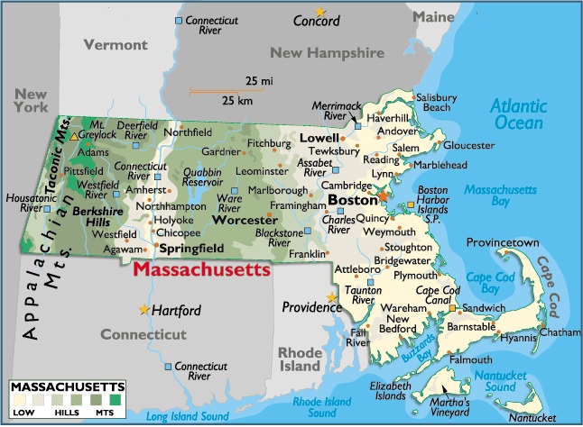
Map of Massachusetts
Capital City: Boston
Location: 42º 35′ N, 71º 05′ W
Popular City: Pittsfield
Location: 42º 44′ N, 73º 25′ W
Commercial City: Springfield
Location: 42º 10′ N, 72º 58′ W
The total area of Massachusetts is 8,284 sq mi (21,455.56 sq km), of which land comprises 7,824 sq mi (20,264.16 sq km) and inland water occupies 460 sq mi (1191.40 sq km). Massachusetts extends about 190 mi (306 km) E-W; the maximum N-S extension is about 110 mi (177 km). Massachusetts is bordered on the N by Vermont and New Hampshire; on the E by the Atlantic Ocean; on the S by the Atlantic Ocean and by Rhode Island and Connecticut; and on the W by New York.
Two important islands lie south of the state’s fishhook-shaped Cape Cod peninsula: Martha’s Vineyard (108 sq mi or 173.88 sq km) and Nantucket (57 sq mi or 91.77 sq km). The Elizabeth Islands, SW of Cape Cod and NW of Martha’s Vineyard, consist of 16 small islands separating Buzzards Bay from Vineyard Sound. The total boundary length of Massachusetts is 515 mi (829.15 km), including a general coastline of 192 mi (309.12 km); the tidal shoreline, encompassing numerous inlets and islands, is 1,519 mi (2,445.59 km). The state’s geographic center is located in Worcester County, in the northern section of the city of Worcester.


You must be logged in to post a comment.